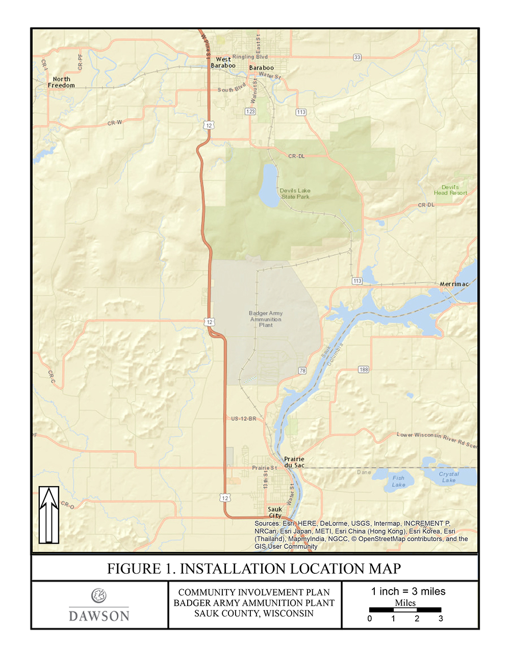
FORMER BADGER ARMY AMMUNITION PLANT
**Please check back often as we are growing this site.**
Resources
Groundwater Information
- Groundwater Quality Website (aka Story Map aka Geonarrative) developed by USGS using Army data
- USGS Scientific Investigation Report - Assessment of Contaminant Trends in Plumes and Wells and Monitoring Network Optimization at the Badger Army Ammunition Plan, Sauk County, Wisconsin
- Remedial Investigation / Feasibility Study for Site-Wide Groundwater at the Former Badger Army Ammunition Plant
- Groundwater Monitoring Reports
- November 2022 Groundwater Data
- September 2022 Groundwater Data
- June 2022 Groundwater Data
- April 2022 Groundwater Data
- March 2022 Groundwater Data
- November 2021 Groundwater Data
- September 2021 Groundwater Data
- June 2021 Groundwater Data
- April 2021 Groundwater Data
- November 2020 Groundwater Data
- September 2020 Groundwater Data
- June 2020 Groundwater Data
- January - May 2020 Groundwater Data
- November 2019 Groundwater Data
- September 2019 Groundwater Data
- June 2019 Groundwater Data
- April 2019 Groundwater Data
- March 2019 Groundwater Data
- November 2018 Groundwater Data
- September 2018 Groundwater Data
- September 2018 Groundwater Data (landfills)
- August 2018 Groundwater Data
- June 2018 Groundwater Data
- April 2018 Groundwater Data
- March 2018 Groundwater Data
- November 2017 Groundwater Data
- October 2017 Groundwater Data
- September 2017 Groundwater Data
- August 2017 Groundwater Data
- 2016 Summary
- Residential Well Sampling
- August 2021
- August 2020
- August 2019
- July 2019
- November 2018
- October 2018
- Residential Well Replacement
- Sampling and Plume map
- WDNR Approved Groundwater Monitoring Plan
Gruber's Gove Bay Information
Data were collected by the USGS to assess mercury (Hg) concentrations and isotopic compositions at Gruber's Grove Bay (GGB), Wisconsin, for future management decisions related to the site. Sediments, soils, and suspended particulate matter were collected for Hg analysis from regions of GGB and upstream sites with no known Hg discharge (Weigand's Bay and Lake Wisconsin). These data were provided for presentation and release to the Restoration Advisory Board for the Badger Army Ammunition Plant and the general public by the US Army Environmental Command.
Information about Badger AAP Cleanup Sites
- 2021 Annual Maintenance Activities for Closed, Covered and Capped Sites
- 2020 Annual Maintenance Activities for Closed, Covered and Capped Sites
- 2019 Annual Maintenance Activities for Closed, Covered and Capped Sites
- 2018 Annual Maintenance Activities for Closed, Covered and Capped Sites
- 2017 Annual Maintenance Activities for Closed, Covered and Capped Sites
- Gruber's Grove Bay
- Settling Pond 2
General Information about Badger AAP Cleanup
- Installation Action Plan
- CERCLA Process
- Cleanup Fact Sheet
- Badger Army Ammunition Plant Historical Overview
Community Information
Partner and Stakeholders
- Wisconsin Department of Natural Resources
- Wisconsin Department of Health Services
- Wisconsin Department of Transportation
- Environmental Protection Agency - Region 5
- Agency for Toxic Substances and Disease Registry
- Citizens for Safe Water Around Badger (CSWAB)
- Baraboo Area Chamber of Commerce
- Sauk Prairie Area Chamber of Commerce
- Ho-Chunk Nation
- Dairy Forage Research Station
- Sauk Prairie Recreational Area
- Sauk Prairie Conservation Alliance
- Town of Merrimac
- Town of Sumpter
- Sauk City
- Village of Prairie du Sac
- Village of North Freedom